| The exhibition has just begun a run in the Regional Cultural Centre, Letterkenny, Co. Donegal. It will be on show until 4 March 2022. |  |
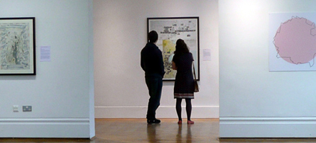
Maps of Northern Ireland are often used to illustrate traditional political divisions, but they conceal a much more nuanced and interesting place. This landscape, rural and urban, is much more than a site of conflict.
This exhibition brings together diverse mapmakers: local historians, activists, artists, geographers and urban planners who interpret our surroundings in different ways. Mapping Alternative Ulster re-thinks our representation on maps.
Culture NI made a video interview with the curator Garrett Carr during the show's run in the Ulster Museum. It is five minutes long and can be viewed here. For the most recent run of the exhibition, Garrett spoke to the Donegal News.
 |
| Touring |
Watch this space for events and future shows of Mapping Alternative Ulster.
Visitor comments
A striking exhibition provoking new insights.
We need these new ways to look at the land.
This exhibition is both fascinating and inspiring we can see maps as quite banal things but the feelings and sentiments that locations can evoke are very clearly displayed here. Many thanks for helping me look at the map of Ulster in a new way.
Really enjoyable! Never thought of the alternative use of maps.
Very inspiring and almost childlike it its joy. My six-year-old also loved it and it will no doubt shape what she next draws.
Made me proud to live here and made me want to draw a map.
Webpage background: Detail from a hand-drawn map by Johnny McKeagney. For thirty years McKeagney charted the land, traditions and people around this hometown in Co. Fermanagh. Many of his maps have been published in a book, click here for more information.